
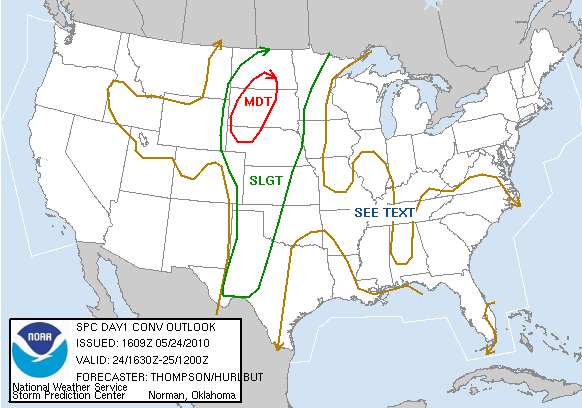


Chase Route SPC Convective Outlook SPC Tornado Prob. NOAA Storm Report
May 24th, 2010, SD Storms and Nebraska Mammatus
A tough chase day
for us, but we were rewarded at the end with a spectacular mammatus display..
Starting in North Platte, NE, our target was somewhere in the area west of
Pierre. We knew it would be a tough chase day: very unstable with little
capping, unidirectional flow which meant that the storms would line out pretty
quickly, and supersonic storm motion in the range of 50-70 mph. The only way to
catch a tornado today would be to place ourselves well in front of where we
thought storms would initiate, and hope that they would mature and drop a
tornado as they screamed by, since we'd never be able to catch up once they
passed. Well, it turned out to be even earlier than we expected and by the time
we got to Murdo, SD on I-90 storms were already blowing up on the warm front in
our target area and along the dry line to our west. Since the warm front storms
were out of reach, we bolted west towards the line of storms coming up towards
Rapid City, SD, but as we got past Wall the storms had already lined out.
Meanwhile, one of the storms well to our north dropped a big tornado, but we had
no way to catch it. We were about 100 miles south of the storm and it looked
spectacular from a distance, but there was nothing we could do. With the warm
front out of reach and the storms to our west forming a massive squall line that
later would stretch all the way to Texas, we blasted back east to try and
intercept a line of storms coming up from Central Nebraska. The surface winds
were AMAZING, regularly gusting into to 40 mph or more and making the drive on
the Interstate a white-knuckle affair.
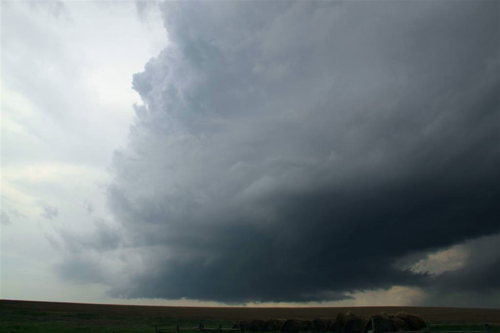
Eventually we got off the highway at Vivian and let one of the cells from the
south come to us. It looked pretty interesting as it closed on our position, but
then lost focus and appeared to be losing intensity as it rocketed by at 71 mph!
It seemed I turned around to talk to someone for a minute, then turned around
again, and the updraft was gone to the horizon!
At this point there were cells everywhere as the uncapped environment along with
3000+ j/kg CAPE turned every updraft into a storm. Eventually, with a squall
line coming from the west, another linear system to our east, and popcorn storms
to our south, we gave up and decided to head for our hotel for the night in
Valentine, NE, expecting to let the squall line run us over for some fun on the
way. As we drove down Rte. 83 towards Valentine, a storm got its act together
for a few minutes and generated a nice wall cloud, but as we paralleled it to
the east it eventually weakened and regardless we could never have kept up with
it.
We finally got nailed by the squall line which had weakened considerably as we
approached Mission, SD. Still we got blasted by high winds (one spotter report
indicated an 87 mph gust near our position) and as we rolled through Mission saw
a tree down in the road. As we continued south, we were now on the back of the
squall line which appeared on radar to have re-intensified somewhat and started
bowing out, and we once again got into heavy wins as the rear-inflow jet of the
line really cranked up.
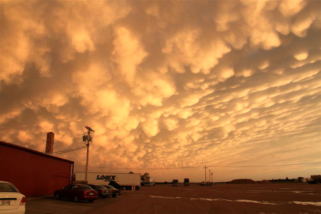
Arriving in Valentine, NE, we headed to the Bunk House for dinner, of course.
Entering town we saw a massive tree that the wind had taken down. We ended the
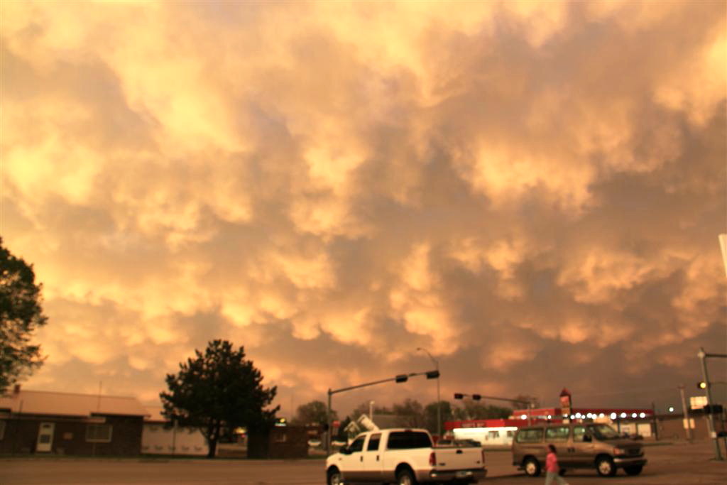
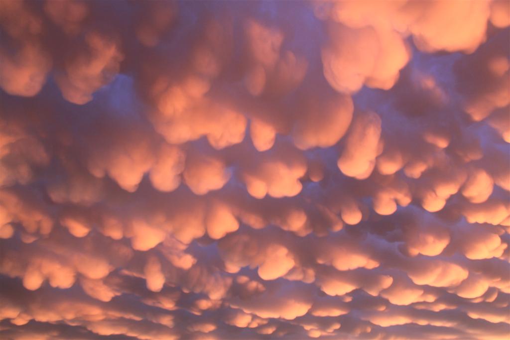
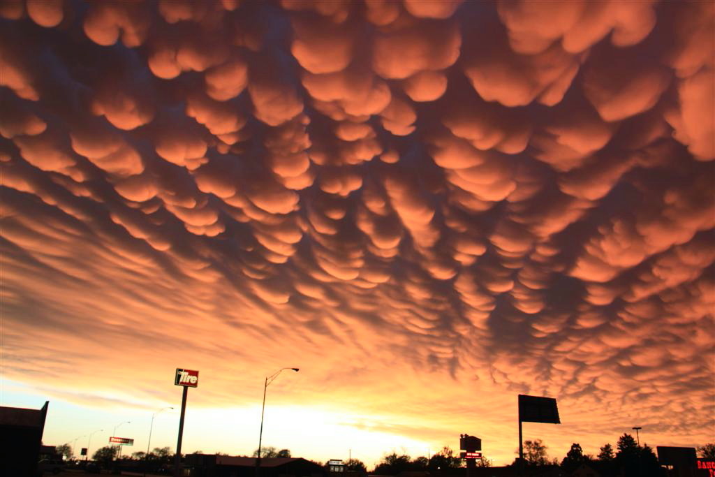
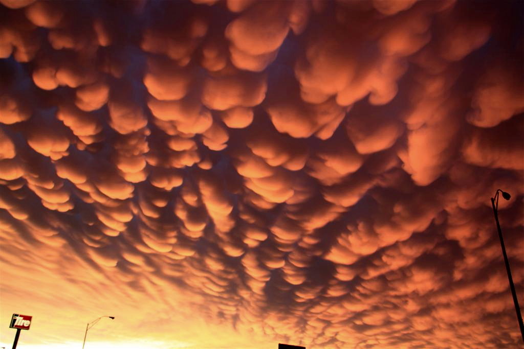
day getting a very, very nice surprise, the best mammatus cloud display I've
seen in my 10 years of chasing.
All in all, an unsuccessful chase day, but the mammatus were a very nice
consolation prize.
Miles for the day: 505.
Chase Route
SPC
Convective Outlook SPC Tornado Prob.
NOAA Storm Report
 |
 |
 |
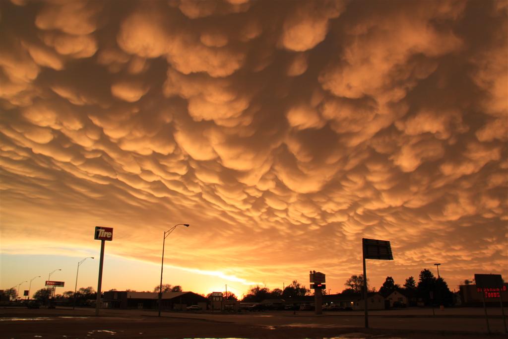 |
| 3000 j/kg CAPE, no cap, meant storms all over the place and a general mess! Plus, they were rocketing along at 60 mph or more! It all made for a very tough chasing day. Here we're just south of Vivian, SD watching a storm fly towards us with a large rain free base. | Eventually with no specific area of storms to focus on, we gave up and headed for the hotel in Valentine, Nebraska. As we neared White River, SD, a storm briefly got it's act together and looked good for awhile, so we reversed direction and stayed with it as long as we could. Here it had developed a nice rotating wall cloud. I love South Dakota's rolling green hills. | After returning to Valentine, where there had been considerable wind damage that day, we stopped for dinner at The Bunkhouse, well known to chasers everywhere. As the Sun set, we were treated to a spectacular mammatus display, the best I've seen, on the back side of a squall line we'd gotten run over by on the way to the town. | The next few shots speak for themselves. Amazing!! |
 |
 |
 |
 |
All pictures (C) Richard Hamel 2017.