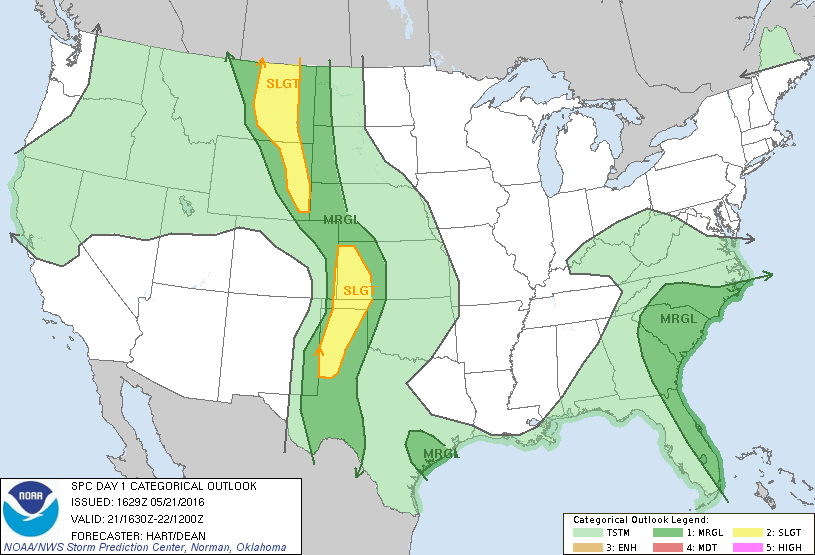

SPC Convective Outlook SPC Tornado Prob. NOAA Storm Report
May 21st, 2016, Leoti, KS Tornadic Supercell
A tremendous chase day on “the day before the day”! We
expected a solid chase day, but not the spectacular show we ended up getting.
Starting the day in Amarillo, the morning model runs made the target obvious:
The triple point, which was expected to be northwest of Garden City, KS by 0Z.
The models forecasted storms to fire down the dry line in Texas late, but the
conditions up north looked better and there was no sure thing that the cap would
break before it got dark in Texas, so we headed north.
After a stop in Garden City for lunch and then again at a
truck stop on the north side of town to evaluate the situation, we decided to
head north towards Scott City, observing the cumulus clouds above the moist
plume to our east wrapping into the triple point, as well as developing cumulus
caused by convergence along the dry line to our west. As we were heading towards
Scott City, the question was whether to continue to head north all the way to
Oakley to position ourselves to intercept storms up near Sharon Springs, or to
wait near Scott City for the towers that were trying to get going west of us to
mature into storms. Ultimately, by the time we got to Scott City there were a
couple of weak storms trying to get started near Lamar, CO, so we decided to
wait to the south and headed to Leoti from Scott City.
On arriving at Leoti, we first moved to an open area west
of the town to watch things develop, and then back into town to let people get
snacks and wait, amongst the significant chaser convergence at the store. While
waiting there, more robust towers started going up and soon we decided to head
west of town again to play with some developing cells out that way. As we got
there we found a cluster of 3 cells just getting underway, with flat bases and
minimal lightning and precipitation cores. The middle one initially seemed to be
the one with the most potential, but soon its front flank core was raining hard,
producing a pronounced rain foot. The northernmost cell then developed a
lowering and looked like it had a hook echo on radar, so we decided to head back
east to Scott City to turn north, since the road north out of Leoti would soon
be cutoff by the group of cores north of us.
Upon stopping east of Leoti, there were now two action
areas: the northern cell which had a distinct flat base with rising scud
attaching to the bottom and the southern cell, which had absorbed another cell
to its south and was now developing a hook echo. Once the southern storm started
showing signs of rotation and a tornado vortex signature, we chose to target
that storm, turned around, and headed back to the west side of Leoti yet again,
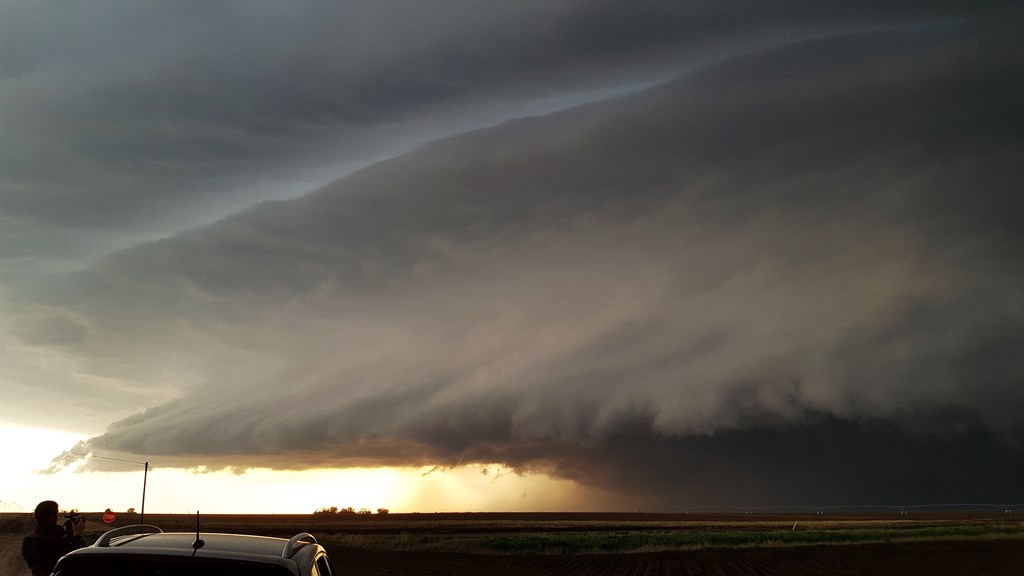
then north on a dirt county road to get a closer look. By now the storm had
taken on supercellular characteristics: rain-free base in front of us,
precipitation core to the northeast, inflow band streaming into the updraft, and
soon a wall cloud. The inflow pumping into the storm from our position was very
strong, a feature that would persist for the next several hours.
We continued to adjust north and east along the
country roads, stair-stepping along roads “M” and “10” and crossing rt. 25.as
the storm became a monster with 2”+ hail in the vault area, which now had a
turquoise tinge to it. One fascinating feature was that the storm had two
distinct mesocyclones right alongside each other, each with its own inflow band.
The storm had already produced at least one brief tornado that we had not been
able to see since it was related to the mesocylone out behind the one in front
of us, but soon it was our turn as the beast generated a brief multi-vortex
tornado with distinct dust swirls to our northwest, though only lasting for
about 30 seconds. The structure of the storm was amazing, with multiple “wedding
cake” layers and striations spinning around the base of the updraft.
At this point the storm had become incredibly
electrified, with white-purple cloud-to-ground bolts hitting nearby to the
front, sides, and behind us! Definitely a “stay in the vans” moment!
We proceeded to the junction of country roads “H” and
“15” and stopped as the road had become very muddy and slick. As we watched the
cell churning to our northeast, the inflow had become the strongest I’ve ever
experienced: I recorded inflow speeds of 48 mph on my Kestrel, by far the
highest I’ve recorded on the device. I was able to lean back into the inflow and
be completely supported by the wind, and at one point I literally could not
close the van door against the blasting inflow. I almost lost my UML Hockey hat
at it was ripped off my head, hit the roof of the van in front of me, and was
lofted about 50 yards down the road before it stopped! Another guide wasn’t so
lucky as his ended up in the field and had travelled at least 100 yards and was
still going when we lost sight of it! The ride out of the muck was wild: The
wind was literally sliding the vans off the road without them even moving! I had
to ease the van to the extreme left side of the road as we tried to inch south,
and every gust slid the van towards the right shoulder a couple of feet. There
was nothing I could have done about it if a big gust pushed us off the shoulder.
Luckily, we finally got to slightly better road conditions and repositioned to
the east, and back north yet again.
Our final stop occurred at sunset and the amazing
structure continued as the updraft was highlighted not only by the setting Sun
but also by the non-stop lightning occurring around the updraft, and in the
anvil of the storm which now extended for miles in every direction, displayed a
beautiful mammatus field right above our position. The storm still had a large
inflow band streaming in from the east and was spinning like crazy as dusk fell,
and we spend a solid hour at the last stop, powerful inflow still to our backs,
admiring the storm. Finally, as the storm died off, we called it a night and
made the easy trip back to Garden City for the night, lightning illuminating
every step of the trip back. It was interesting to note that because the anvil
had spread so far, Scott City was in the midst of constant lightning overhead,
yet not a drop of rain would fall there that evening with the precipitation
cores miles to the north.
What a chase! With the storm only moving 5-10 mph, it was
simple to get wherever we wanted to get the best view. The structure and
experience chasing this storm was awesome, definitely in my top 2 or 3 storms of
all time for the non-big tornado storms I’ve chased. Hard to believe this
powerhouse developed with access to only a portion of the conditions the system
moving in would bring in the following days.
Miles for the day: 424.
SPC
Convective Outlook SPC
Tornado Prob.
NOAA Storm Report
 |
 |
 |
 |
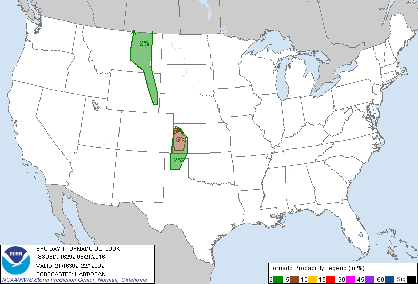
| Back on the chase! But first, the group enjoys lunch in the Sun in Garden City, KS on the way up towards the Scott City area. |
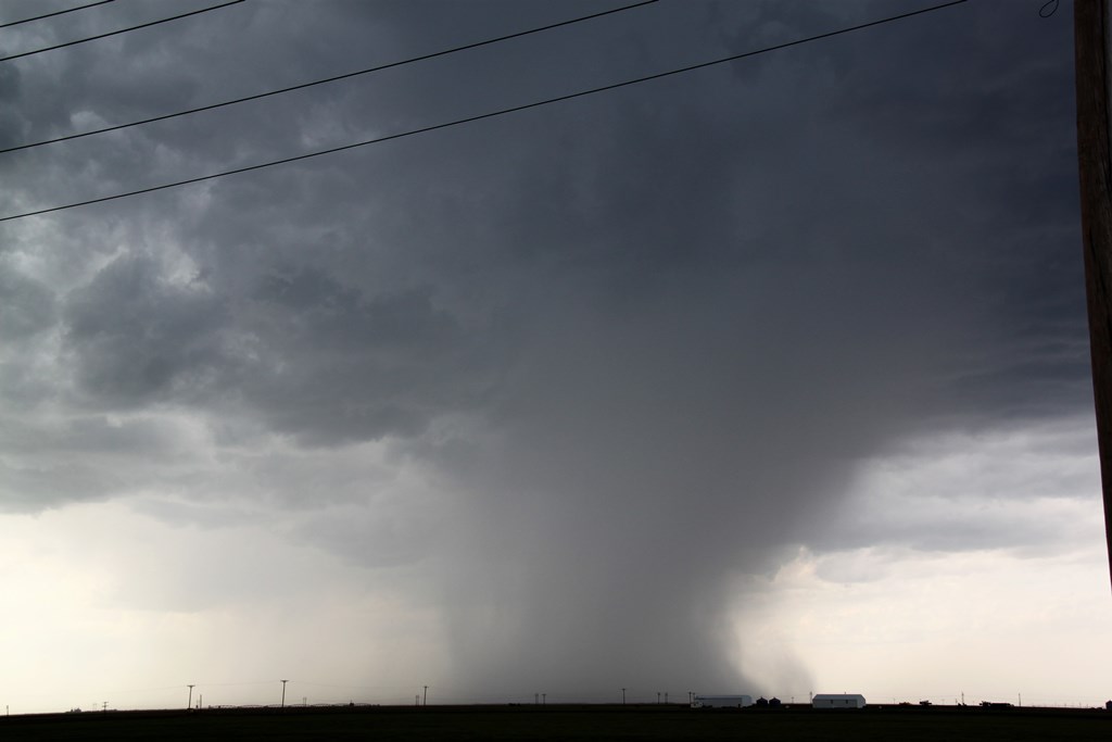
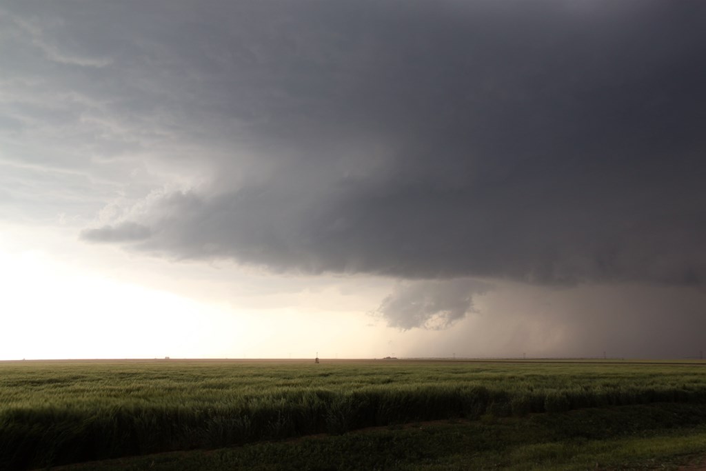
West of Scott City waiting for initiation in the grasslands of Kansas. | Now watching a cluster of three cells near Leoti, KS. Initially the center one looked best but soon it opened up a big rain core that produced this rain foot. | A broader view, soon we gave up on the center storm and targeted the more northern storm that was starting to take over the show. |
 |
 |
 |
 |
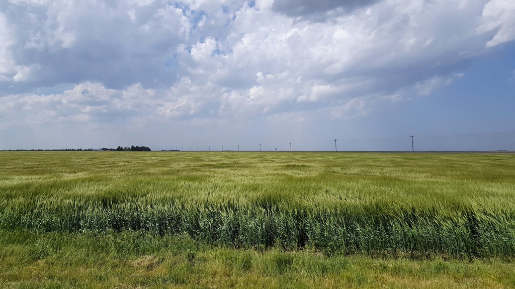
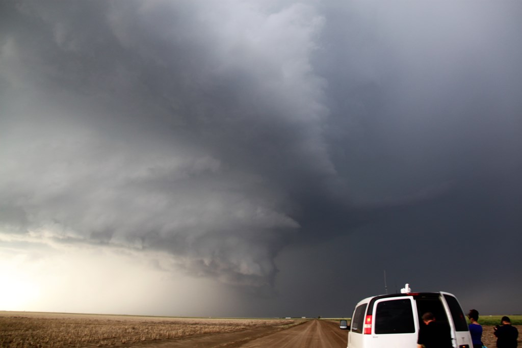
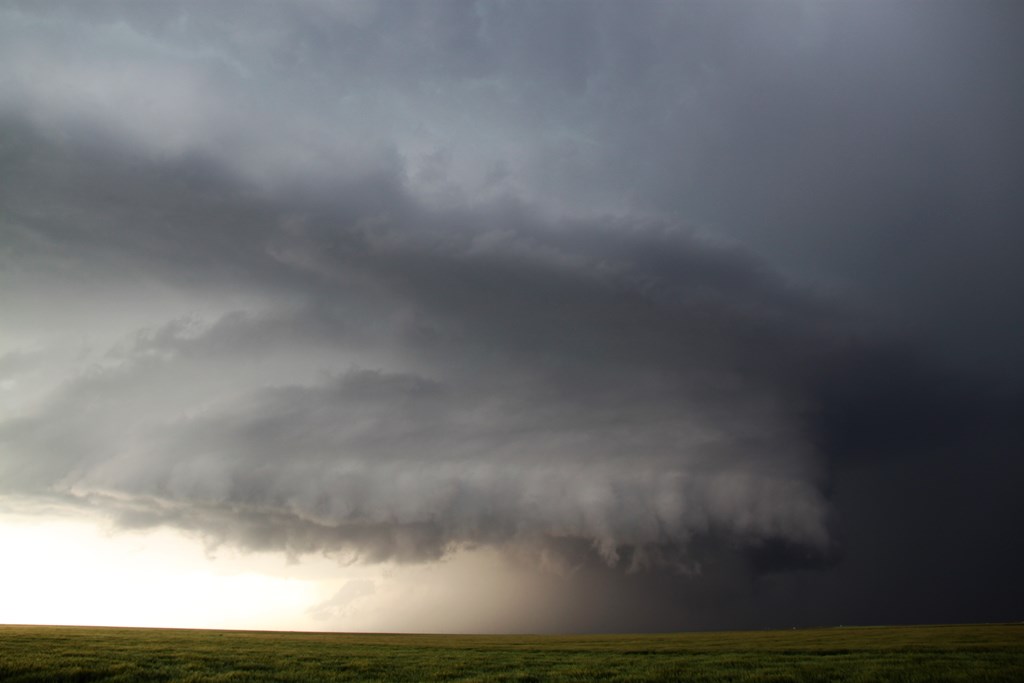
| We headed back east to Scott City and then north. There were now two storms of interest: To the north, this storm to the north, with scud rising into the flat base, and another to the south that was starting to develop a hook echo on radar. Once that storm started showing signs of rotation, we headed south and west towards Leoti again. | Now in the county roads west of Leoti, the structure-fest begins!! | The storm very quickly got organized, developing a collar cloud and showing clear signs of rotation. | Well defined vault area. |
 |
 |
 |
 |
| The fully developed storm churning away to our north. | Dual mesocyclones! The storm now had to parallel but distinct areas of rotation. Around this time we received reports that a brief tornado had been observed off the northern rotation, but we could not see it from our vantage point. | An HP monster! We soon observed a brief multi-vortex tornado near the lowering to the bottom left of the picture. Additionally in the inflows winds were incredibly strong, actually sliding the vans along the road when they weren't even moving! | After a wild ride on mud roads getting blown all over the place by the 50 mph inflow, we got our in front of the storm at sunset. Spectacular structure! |
 |
 |
 |
|
| Flying saucer updraft with the Sun going down behind. | Spinning like a top and still sucking in inflow. | And to top it off, a nice mammatus display directly above us. |
All pictures (C) Richard Hamel 2017.